A summary of a suggested route.


Route of the Exodus Revisited

Some time ago I wrote an essay on the route of the Exodus at the time of Moses. In that essay I evaluated some of the more popular opinions about where the children of Israel traveled. My assessment of alternative opinions has not changed, but with the availability of Google Earth, some refinements to my conclusions are possible.

In this essay I will not address alternative views. I will simply trace what is my best guess for the route, given the Scriptural information.

My views do not always agree with accepted scholarship. Part of that is because the “scholars” themselves often do not agree with each other, and conflicting views cannot all be correct. And if some scholarly views are incorrect, it’s possible they all are. Even more, most of what passes for “scholarship” in the study of this topic is based on the assumption that the Bible is merely a collection of human writings written by biased authors with their own personal agendas. These “scholars” reject the idea that the Bible is a totally reliable record of what really happened. In addition to their anti-Scriptural bias, secular scholars are too often motivated by their own pride and greed and have a tendency, once their views find some acceptance, to ridicule and dismiss any alternative views lest their prestige and income suffer. That’s not scholarship, but arrogance.

At times the Bible is hard for sinful human minds to understand and it is possible that a few flaws were introduced into the text by fallible copyists, but I believe we must start with the premise that the Bible, as originally recorded, was inspired by God and started out as 100% true and accurate. Therefore, we ought to start with what we have in the Bible and suspect a copyist’s error only when it’s the kind of error a copyist is liable to make or if there is a clear contridiction between different Bible passages.

Where “accepted scholarship” agrees with the Bible, I have no problem agreeing with it. There are both Bible-believing and Bible-denying scholars. Much scholarship applies much more study than I have been able to apply. I am not a scholar of ancient history, but the topic has interested me for decades. But most of all I am a student of the Bible and am convinced that in answering questions about the Bible, the Bible itself must reign supreme, even if it leaves some questions unanswered.

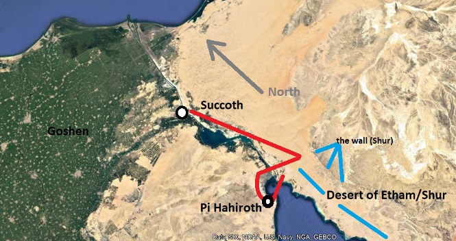
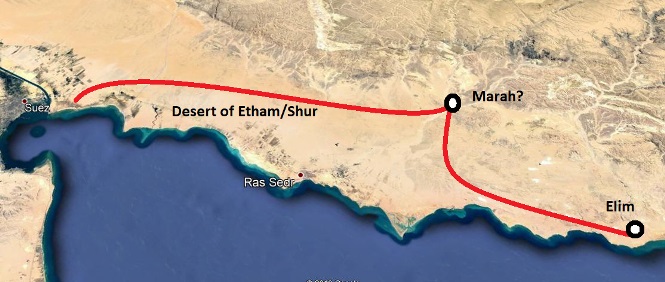
I can start on a point of agreement with most scholarship. The land of Goshen where the Israelites lived is most likely in the southeastern portion of the Nile delta. The Bible does not tell us where Goshen was, but concluding it was in the Nile delta does not contradict Scripture. It’s possible it was somewhere else, but given the information available, it’s currently the best conclusion.

The first stopping place after leaving Goshen at night was Succoth (Ex. 12:37). This was not so much a stopping place, but a gathering place or staging area. The people came from their homes scattered throughout Goshen and assembled as one large group. I can agree with the scholars also on this location. It was probably in the vicinity of present-day Ismalia.

The daylight hours of the first day were not spent traveling. It was a time for consecration and probably some organization. It was the first of the seven days of the feast of unleavened bread.

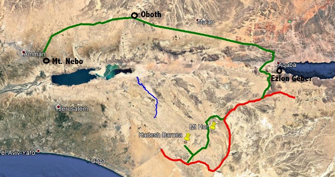
Moses knew from the start that he was to lead the people of Israel out of Egypt, first to Mt. Sinai (also called Horeb), then to the promised land of Canaan. But his request to Pharaoh was to take them three days into the wilderness to worship (Ex 8:27). Pharaoh didn’t want to grant even that. He would likely never have given permission, even after the tenth plague, had he known they would be leaving for good.

My conclusion is that after at least a day at Succoth, they traveled the three day journey that corresponded with the request to Pharaoh and put them at Etham on the edge of the desert. (Ex. 13:20) The question is: where is Etham on the edge of the desert?

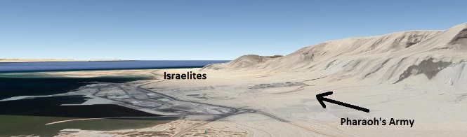
It cannot be to the north or northeast of Succoth, for the “way of the Philistines” (Ex. 13:17) was denied them. From Succoth it was toward the Red Sea. (13:18). But that leads to another question: what “sea” is the Red Sea? Every Scriptural reference, from the ability to travel three day’s journey in that direction, and from references that clearly apply the name to the Gulf of Aqaba, the Red Sea cannot be any other body of water other than what we still call the Red Sea today. The argument that says the “sea of reeds” (as it translates from Hebrew) must be a small reedy lake is based on the rejection of the possiblity of the miraculous. As to whether the Red Sea here is the Gulf of Suez or the Gulf of Aqaba (as some claim), it has to be the Gulf of Suez. Note that they “at Etham” before crossing the Red Sea, and they were “in Etham” for three days (Numbers 33:8) after crossing the sea. That means that the edge of the desert at Etham must be within a three-day journey from Succoth, and that the crossing has to be close to that.

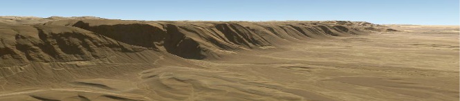
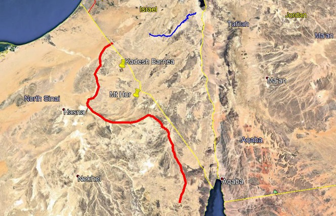
The name given to the desert in Exodus 15 helps. There it is called the “desert of Shur”. Every Scripture reference to Shur places it somewhere southwest of what we now call Palestine, somewhere “opposite Egypt”. The word “Shur” translates as “wall”. While some people think this wall was a man-made wall, perhaps of some fortress, I think it better fits the geography of the area. On the eastern side of the coastal plain starting about 50 miles south of Succoth is a long fairly straight escarpment that could well be called a wall. 50 miles is a reasonable distance for three days of travel both night and day.

Image of what might have been called the Shur escarpment - Copyright 2020 Google, Image Copyright 2021 Maxar Technologies, Copyright 2020 ORION ME, Image Landsat/Copernicus

Once at Etham on the edge of the desert, God gave an interesting instruction. “Turn back and encamp at Pi Hahiroth. (Ex. 14:1) This, at first, seems strange. If they were headed for Sinai as God had instructed Moses, why would they turn back? I think that “turn back” actually means “turn west”. The Hebrews often referred to east as forward and west as backward. There was a reason for this instruction. “Pharaoh will think, ‘The Israelites are wandering around the land in confusion, hemmed in by the desert.’” (Ex. 14:3)

Pharaoh, no doubt, had spies out watching the Israelites. As long as they were within the three-day distance, he had no real concern. He didn’t like it, but he had agreed to a three-day journey. But once they turned west, it was evident they were not coming back north. When the spies got back to Pharaoh and told them what direction the Israelites were going, Pharaoh concluded, “We have lost their services!”

Once the Israelites turned west, the spies took, perhaps, a day or two to race back to Pharaoh, and Pharaoh had a day or two to muster his troops and come after the Israelites, catching up to them at Pi Hahiroth on the shore of the Red Sea. (My location for Pi Hahiroth is a guess based on the narrative and my conclusion about the location of the Red Sea crossing.)

Copyright 2020 Google, Data SIO. NOAA, U.S. Navy NGA, GEBCO, Copyright 2020 ORION ME, Image Landsat/Copernicus

I am guessing that the royal city during the life of Moses was not Thebes, Memphis, or what is now Cairo, for these all seem too far away to fit with the narrative of Moses being found by Pharaoh’s daughter somewhere near where the Israelites were living and with Moses being able to meet with Pharaoh and with Israelites with little time between their meetings. The founder of the Twelfth Dynasty, Amenemhat I, moved the capital city from Thebes to Itjtawy for the latter portion of his reign. The location of Itjtawy is unknown (though some conclude it was upriver from Memphis). To be sure, Jochebed and Amram may have lived upstream from either Thebes or Memphis, for the Bible does not say that every Israelite lived in Goshen; but every Israelite did have to get from wherever they were to Succoth in just a day or two. Succoth is about 75 miles from Memphis, the closer of those two cities. It’s possible Succoth was farther west than the commonly accepted location, within a day’s journey from Memphis. (2020 update: I’ve learned that there was a summer palace at Avaris in Goshen, pretty much surrounded by a Semitic community. Moses’ infancy could have been in summer and the Pharaoh of the Exodus could have been at his summer palace earlier than usual that year.)

Associating the Twelfth Dynasty with the time of Moses (at or before his birth) does not agree with “accepted scholarship.” But as you already know, that doesn’t bother me. “Accepted scholarship” on ancient Egyptian history isn’t all that certain. The historical writings can almost all be traced through just one man, Manetho, who himself was a Greek who lived long after the events he wrote about took place and was dependent on his sources. Even Manetho’s writings are incomplete. We know of him primarily through Josephus, who quoted Manetho extensively. The listing of kings by Manetho as quoted by Josephus is the basis for almost all ancient Egyptian scholarship today. Archaeology has yielded some additional writings, but these are primarily financial and trade records or ego inflating tales of daring-do by rulers who regulary tried to erase all trace of former rulers and opposition. Secular archaeology also has a tendency to date things as far into antiquity as possible, especially if its “facts” can be used to discredit the Bible record. The problem with the Manetho/Josephus king list is that there is evidence that strongly suggests Manetho did not recognize when Pharaohs used multiple names such that his lists show as separate entries dynasties that should have been recognized as identical. The result is that there could well be hundreds of extra years written into Manetho’s “history”.

I think it’s very likely that the Pharaohs of Moses’ were of the Twelfth and Thirteenth dynasties, which ended in the collapse of at least northern Egypt with the invasion of the Hyksos, who took over Egypt until the rise of what is called the “New Kingdom.” Josephus says that the Hyksos took over Egypt without opposition. I think there is good reason to conclude that the Hyksos invaders were the Amelekites, a group of which attacked Israel at Rephidim on the way to Sinai. The fact that Pharaoh and his army were drowned at the bottom of the Red Sea would explain why they found no opposition. That the Amelekites ruled in Egypt would also explain why the Israelites were not affected much by “Egypt” during the time of the Exodus, Joshua, and the Judges. They were affected by the Amelekites until their defeat by King Saul. With the Amelekites out of the way, the New Kingdom in Egypt could become established.

But back to the main theme.

When Pharaoh came with his army, the Israelites thought they were in an impossible situation. (Ex. 14:10-12) This fits well with the geography of the place that I think may have been Pi Hahiroth. With Pharaoh coming at them from the north, they were boxed in between Pharaoh on the north, mountains on the west and south, and the sea on the east. There was nowhere to escape.

Copyright 2020 Google, Image Copyright 2021 Maxar Technologies, Copyright 2020 ORION ME, Image Landsat/Copernicus

I find it interesting that at that point, before God told Moses to raise his staff, he told Moses to tell the Israelites to go forward, break camp, get going – when it appeared there was no place to do that.

The reason for the appearance of confusion becomes clear. God was bringing Pharaoh into his trap. Had they not turned “back”, Pharaoh could have caught up with them anywhere from Etham to Sinai and beyond. But God was about to eliminate that threat completely.

Concluding the crossing of the Red Sea took place here is supported further by the underwater topography of the sea at this place. The depth chart on the next page shows an area of shallower water reaching all the way across the less than six mile reach of water, with deeper water both north and south and a depth of no greater than 50 feet. Going down 50 feet and up again in six miles is not hard. The six mile distance could easily been traversed by the whole company overnight. It is both shallow enough to be a reasonable walk for the Israelites and deep enough to drown Pharaoh’s army once the waters returned to their place.

Although the Bible does not tell us on which day of the exodus the Red Sea passage took place, I think it may have corresponded with the end of the feast of unleavened bread. A day or two at Succoth, three

days to Etham and a couple of days going “back” to camp at Pi Hahiroth. These were the days when Pharaoh still posed a threat. But that night was a new day, a day of deliverance, a day for rejoicing.

Next came three days of travel without water in the Desert of Etham/Shur (Ex. 15:22) until they came to Marah. The location of Marah here is a guess.

Edersheim notes, “The spring of Hawwarah is still considered the worst on the whole road to Sinai, and no means have ever been suggested to make its waters drinkable.”1 My resources, however, do not give me precise enough information to be able to locate it. One of my maps identifies the wadi I’ve chosen as Wadi Al Siq. In the upper reaches of this wadi basin are some very dark rocks, which could be the cause of the bitterness, but knowing nothing but the color of those rocks as shown on Google Earth can’t confirm anything.

1Alfred Edersheim, Bible History Old Testament, p. 93

Copyright 2020 Google, Data SIO. NOAA, U.S. Navy NGA, GEBCO, Copyright 2020 ORION ME, Image Landsat/Copernicus

Elim is identified by most Bible scholars with Wadi Gharandal, which has good water supply and trees yet today. The Israelites stayed at Elim a number of days. In Moses’ day there were 12 springs and 70 palms. Ex. 15:27 says they camped by the water. That could mean by the stream or by the sea shore. In my earlier paper I addressed some of the possible alternative sites for Elim, but for this paper I’m just going with my best conclusion, given the information I have.

South of Elim the steep bluffs bump against the shore, making travel there difficult. Likely they would have gone up a wadi somewhat inland.

Copyright 2020 Google, Image Copyright 2021 CNES / Airbus, Copyright 2020 ORION ME, Image Landsat/Copernicus

Numbers 33 indicates that after they left Elim they camped one last time on the shore of the Red Sea. There is nothing to indicate exactly where this camp was. I’ve chosen two places: one right on the coast and the other about three miles from the coast. The alternate is noted because the topography would likely have required them to backtrack to that point if they camped right on the coast. “By the sea” does not need to mean immediately on the shore, but can include “close to the sea.” The Red Sea would still have been visible from the alternate camp site, and was, perhaps, the last time they would have been able to see the Red Sea along their route before coming to Sinai. The route shown here from Elim to either Red Sea camp is mostly used by a modern highway.

Exodus has only the Desert of Sin between Elim and Rephidim. Numbers 33 has the Red Sea camp, the Desert of Sin, Dpphkah, and Alush between those locations. The topography north of Elim is a coastal plain. South it is more rugged. It would be logical that this would be recognized as a change from the Desert of Etham/Shur to the Desert of Sin. I think the Exodus account generalizes the region and the Numbers account is more precise, with the Desert of Sin proper being the granite mountains that dominate the southern part of the Sinai peninsula. An arm of those mountains reaches north as far as the Red Sea camp, but there are a couple of passes by which one can cross these mountains into the interior. I’ve selected the narrower one simply because it would be easier to get there from my choice of the Red Sea camp, for it simply goes up the valley. In the pass between the coast and the interior could be where manna was first given.

Copyright 2020 Google, Image Copyright 2021 CNES / Airbus, Copyright 2020 ORION ME, Data SIO, NOAA, U.S. Navy NGA, GEBCO

My route from Elim to Sinai differs from every other suggested route, but I believe I have good reason to settle on this conclusion for now. Most of the other proposed routes would be much more difficult. This one offers a relatively easy route to the interior and a Mount Sinai that fits the Scriptural characteristics. More on that a bit later.

Copyright 2020 Google, Image Copyright 2021 Maxar Technologies, Copyright 2020 ORION ME, Image Landsat/Copernicus

This route enters the interior by Wadi el Homur and makes an easy transition to the Wadi el Garf and to the Wadi Sieh. The whole way from “Manna begins?” to Rephidim is fairly flat. The location of Dophkah shown here fits with the meaning of the word that refers to the knocking sound associated with copper mining, and there were Egyptian copper mines in this area. I acknowledge, however, that while this route is fairly flat, I understand the sand is fine and hard to walk on. Cart wheels would sink in.

There are those who argue that God would not have led them so close to an Egyptian mine with its expected guards. But I’ve learned that these mines were operated only seasonally, and not during the season when the exodus occurred. As far as soldiers are concerned, remember that Pharaoh and his army were at the bottom of the sea.

The location of Rephidim is closely tied to Mt. Sinai (see next paragraph), but has Scriptural requirements of its own. It must a place without water. It must be a place where the Amelekites would likely attack their slower rear guard (Dt. 25:17-18)

My top candidate for Mt. Sinai has not, to my knowledge, been suggested by anyone else. But I have settled on it for the present because it fits a number of Scriptural requirements. It’s close enough to Rephidim for Moses and the elders to go to Horeb and get back to Rephidim without weeks of travel. Water from the rock could flow toward Rephidim. There’s room for the whole people to gather at the foot of the mountain and to set up their camping arrangments. It lies on a logical line of travel between a viable location for Jethro’s home and Egypt and at a distance from both Egypt and Jethro so that Aaron could set out from Egypt and Moses could go to Jethro and back and meet at Mt. Sinai. It is on the west side of a desert area (or “back” side). It’s in its own desert (they left the Desert of Sin and entered the Desert of Sinai – a different geographic area). Finally, there is a logical route of travel from Sinai to Kadesh.

The mountain I’m calling Mt. Sinai is known as Gebel Dalal. It doesn’t look very impressive on Google Earth, but the Bible does not say it was impressive apart from God’s presence, nor the highest mountain in the region. (Note that Google Earth rounds off land features. The points on which their computers build a terrain model are too far apart to get all the rugged detail of rocky points.)

The Amalekites' main region was between Egypt and Canaan close to the Mediterranean Sea. The River of Egypt (the Wadi Al-Arish) would have been the major drainage basin of the Amalekites. The upper regions of this basin are just to the north of this choice for Rephidim and there is easy access from the headwaters to the valley. The Amalekites might have been attacking to prevent an invasion through their "back door", or they may have attacked as a part of their military expansion that went also into Egypt, where the absence of an Egyptian army enabled them to take Egypt over without resistance. Copyright 2020 Google, Image Copyright 2021 CNES / Airbus, Copyright 2020 ORION ME, Image Copyright 2021 Maxar Technologies

This Mt. Sinai is but four to five miles from this Rephidim. This Rephidim appears to be a dry sandy bowl. Its name (“resting place”) fits with the trek they had from the place where manna started. Crossing the area immediately to the left of Sinai takes them out of the sandy stretches of Wadis Homur, Garf, and Sieh into a new geographic region. There is a pass at the north side (top) of this Rephidim that would give the Amelekites easy access, for just over that pass are the upper regions of the Wadi el Arish (the River of Egypt) that empties into the Mediterranean in the heart of Amelekite territory.

One of the factors in selecting a viable candidate for the location of Mt. Sinai is whether or not there is an adequate space for the camping arrangement outlined in Numbers 2. Before this arrangement was given the people could have camped in a much more concentrated space. But once it was given, they needed the space. I have attempted to come up with a figure that is, in my opinion, the minimum amount of space necessary for this camp arrangement. I calculated on the premise that on average each counted man had one wife and one child and that each person had 32 square feet (one 4×8 sheet of plywood) of space in which to camp (sleep, cook, etc.). I doubled that for any animals they might have with them. That results in a camp area measuring at least 1.59 by 1.52 miles.

There is a broad relatively flat area very close to my selection for Mt. Sinai that is large enough for such a camp arrangement. I’m guessing that the people gathered around the base of the mountain for the giving of the Ten Commandments and may have been randomly scattered in the area before the instructions of Numbers 2. Number 2 through most of 10 is preparing to set out from Sinai. It’s logical to conclude that they would get ready on the side of Mt. Sinai toward which they would be going.

When God gave the Ten Commandments, the Israelites could have been gathered more than half way around this mountain, somewhat to the left of the shaded square. Later the arrangement for their encampments was given. This shaded square shows the estimated limits of the whole camp, not the details of where each tribe was located. At this location, slightly east of "Sinai" there is a wide nearly flat area that would have room for such a camp. Note, however, that this does not prove that my selection for Sinai is the correct one, merely that it fits the criteria. -- Copyright 2020 Google, Image Copyright 2021 CNES / Airbus, Copyright 2020 ORION ME, Image Copyright 2021 Maxar Technologies
The primary reason for rejecting the traditional site of Mt. Sinai is the argument that there is no adequate space for the whole camp of Israel. This shows two possible locations near the traditional Mt. Sinai and in both cases the valleys are too small. -- Copyright 2020 Google, Image Copyright 2021 CNES / Airbus, Copyright 2020 ORION ME

From Sinai they traveled three days. If we conclude that the Taberah incident happened after three days, the location shown would fit, being a little over 30 miles from Sinai. They evidently did not camp at Taberah, for it is not listed in Numbers 33. From there they would have had to work their way through the narrow canyons to what is labeled as Kibroth Hattaavah, where the great masses of quail came from the sea (Nu. 11:31). There appears to be enough room for the camp arrangement there. The route from there to what is labeled Hazeroth is fairly easy up the wadi.

One of my maps labels the area just west of the K of Kibroth Hattaavah on this map “El Hazim”, which is a close cognate of Hazeroth and is, like Hazeroth, a plural. That suggests the Hazeroth would better be located where Kibroth Hattaavah is shown; but that would mean finding another location for Kibroth Hattaavah. It could have been on the coastal alluvial plain called Neviot, where there is room for a camp, but that would mean retracing their steps. Or, perhaps, Kibroth Hattaavah should be located where I have placed Taberah, and Taberah happened during the three day journey from Sinai.

The route after Hazeroth is not easy to trace. Consider the various lists of places given in Scripture:

Numbers 10-12 puts the Desert of Paran (and Kadesh in Paran) immediately after Hazeroth. From there the spies are sent out and to there they return. Deuteronomy 1 says the spies were sent from Kadesh-Barnea. Exodus 33 follows Hazeroth with Rithmah, and the first Kadesh in the list is Kadesh in the Desert of Zin. Both Numbers 33 and Deuteronomy 10 have Jaakan, Moserah(Mozeroth), Guggodah(Haggidgad) and Jothbathan, but the order is different. Dt. 10 identifies Moserah with the place of Aaron’s death, but Exodus 14 and 33 say it was at Mt. Hor. Exodus 33 puts Ezion Geber – at the northern limit of the Gulf of Aqaba/Red Sea – immediately before Kadesh in Zin.

Most scholars conclude that there was one Kadesh and that the Israelites were there more than once. Might there have been two Kadeshes, one in Paran (=Kadesh Barnea) and one in Zin? Deuteronomy 1 equates the Kadesh in Paran with Kadesh-Barnea. But other passages indicate that Kadesh-Barnea is in the Desert of Zin, including Dt. 32:51 and Joshua 15:1,3. The southern portions of the allotment to Judah included part of the Desert of Zin.

Copyright 2020 Google, Data SIO. NOAA, U.S. Navy NGA, GEBCO, Copyright 2020 ORION ME, Image Landsat/Copernicus

Most scholars also conclude that Kadesh is located at Tell el-Qudeirat at 30°38’30” N Latitude, 34°24’40” E Longitude. That location has a small oasis valley that hardly seems large enough for the Israelite camp, but most scholars figure the Bible largely exaggerates the population of Israel. So I question that selection for Kadesh. Two other locations offer both more room and better access for the spies to head into Canaan: the area around Nitzanae Sinai and Kzi’ot and the area around Revivim. Interesting that next to Revivim is a town called Retamim. Edersheim, Unger’s Bible Dictionary, and P.E. Kretzman all consider Rithmah an alternate name for Kadesh or a place very close to Kadesh.

Copyright 2020 Google, Data SIO. NOAA, U.S. Navy NGA, GEBCO, Copyright 2020 ORION ME, Image Landsat/Copernicus

At left is a Google Earth image of the “accepted” site of Kadesh-Barnea with a camp size rectangle superimposed. The Israelites would not have fit into the little wadi.

The Bible doesn’t tell us exactly where Kadesh-Barnea was located. All it says is that when they were there, Moses said, “You have reached the hill country of the Amorites, which the Lord our God is giving us.” “Go up and take possession of it.” That could mean either that they were in the hill country or that they had come to the edge of it.

But was Kadesh in Paran or Zin? “Scholars” will easily dismiss the difference by claiming a flaw or contradiction in the Bible. But if we believe in Verbal Inspiration and if we believe we have the original words, we must conclude there is no contradiction. How can both be true? I don’t know for sure, but one possibility is that at the start of the Exodus, the whole region was called Paran, but by the end of the Exodus the region was divided into more specific regions.

My offering as the easiest route from Hazeroth to Kadesh. Note that I have selected the Nitzanae location for this graphic, but only a slight variation at the end could lead to either the traditional site or the Revivim location. I lean toward the Revivim site, but I have nothing but a subjective evaluation of the topography to incline me so. The yellow lines are the current boundaries of Israel and Jordan. -- Copyright 2020 Google, Data SIO. NOAA, U.S. Navy NGA, GEBCO, Copyright 2020 ORION ME, Image Landsat/Copernicus

Once the spies returned, how long did they stay at Kadesh-Barnea? One passage says they stayed many days in Kadesh. Another passage earlier in the same chapter seems to tell them immediately to turn to the Red Sea. And if Rithmah is Kadesh, and they stayed there until the last year, then what about all those other places listed in Numbers 33? Note that Numbers 20:1 says that in the first month they arrived at the Desert of Zin. If, as noted above, this is the first month of the 40th year, they must have been arriving at least a second time. God’s sentence was not that they would be staying in one place for the rest of 40 years, but that they would wander.

Deuteronomy 10 clearly says Moserah is where Aaron died, and Numbers clearly says he died at Mt. Hor. These must be two names for the same place. In fact, one of the researchers1 has noted that the plain around the base of the mountain called Araif en Naqa (at 30°21’30” N, 34°26’35” E), which is his choice for Mt. Hor, is called the Wadi Mizeria, a close cognate of Moseroth. He’s not alone in saying that the people camped at the valley of Moserah while Moses, Aaron, and Eleazar were on the mountain. Since Numbers 33 mentions both Moseroth and Mt Hor, they must have been there at least twice.

An interesting possibility is shown also by the places called Moseroth, Jotbathah, Hor Haggidgad (or Guggodah), BeneJaakan (or wells of Jaakenites) in Numbers 33 and Deuteronomy 10. We’ve already seen that Moseroth/Moserah is Mt. Hor. These four names come in sequence in both lists, though with a different order for Moseroth and BeneJaakan. The word for well in Hebrew is BR (We write “beer”.). There’s a fairly good argument that says this is the origin of the word “Barnea” of Kadesh-Barnea. BeneJaakan could be abbreviated as BeneYa (or Benaiah), and substituting BR at the beginning yields Barnea. If that is the case, then BeneJaakan/wells of Jaakenites is yet another name for Kadesh. Further, if that is the case, note the close association between Barnea/Jaakan and Moserah/Hor. It would appear that they were at Kadesh and Mt. Hor more that twice each. Perhaps like this:

  1. From Hazeroth to Rithmah/Kadesh when it was still considered part of Paran. Then immediately turn toward the Red Sea after the spies.

  2. Come back to Kadesh/Jaakan after Hasmonah by way of Mt. Hor/Mozeroth.

  3. (Deuteronomy) From Kadesh back to Mt. Hor/Moserah, to Haggidgah, to Jothbathan, and back to Kadesh.

  4. From Kadesh, back to Haggidgah, to Jothbathan again, to Abronah (wandering around Mt. Seir – Abronah means “pass” and could refer to the pass between the waters that flow to the Mediterranean and those that flow into the Arabah.), Ezion Geber, and

  5. back to Kadesh (when Miraim died), then to Mt. Hor when Aaron dies, then to Zalmonah, etc., during the last year of the Exodus.

The many days at Kadesh could have come at either 2 or 3. The waters of Meribah probably occurred in either 4 or 5.

A question: why would they go all the way back to Kadesh from Ezion Geber if they were already at the Red Sea (That’s where Ezion Geber is.) only to turn around again and come back that way to go around the east side of Edom and Moab? My answer is purely a guess. God told Moses (Dt. 2) turn and go north; it’s been 40 years. So, Moses, thinking that the way into the promised land was via Kadesh, went back there. Perhaps God was thinking to himself, “Not that way north, Moses; the other way north.” But God worked so they ended up going the other way north.

Once again in Kadesh at the beginning of the 40th year, it seems odd that Moses did not even try to go straight in past Arad, Hebron, etc.. Instead he asked to use the king’s road through Edom that would take him down into the Arabah south of the Dead Sea. Did he consider the more direct route closed (by the events 38 years before)? The Bible doesn’t say.

His request was denied and God would not allow them to fight the Edomites. So they turned toward the Red Sea again by way of Mt. Hor, where, this time, Aaron died.

A host of places have been argued as the location of Mt. Hor. Some are north to northeast of Kadesh. Petra, deep in Edomite territory on the east side of the Arabah is another; Mount Karkom, also in Edom on the west side of the Arabah yet another. The Scriptural requirement is that it be somewhere along the route from Kadesh to the Red Sea, (Nu. 21:4) and that it not be in Edom. The best candidate I’ve seen, as already noted, I learned about through the writings of David Fainam: Gebel Araif el Naqa. That location fits well with the Biblical record. Moses wanted to use the highway through Edom, but the king of Edom refused. The king of Arad, perhaps, thought, “That means they’re coming this way!” But by the time he musters his forces and goes out to meet Israel, they’re already heading south. So he caught up with them and captured a few. Either a contingent of soldiers was sent back to deal with the king of Arad or a vow to punish Arad was fulfilled during the time of Joshua.

The locations of the next two camps (Zalmonah and Punon) are unknown. Oboth has been linked to Al Hasa on the east side of Moab at the Brook Zered. All the other locations after Oboth are east of Moab. We don’t know where the Israelites turned north again after this final push toward the Red Sea. Topography suggests it was almost at Ezion Geber, where the Wadi Ytum comes from the Arabah and turns north. This is a second king’s highway that continues north from there all the way to Damascus and beyond. It is on the east side of both Edom and Moab, but touching their boundaries such that the Israelites could buy supplies from them.

1David Faiman, “The Route of the Exodus”, Dor le Dor, 14.4 (1986), p.213
Copyright 2020 Google, Data SIO. NOAA, U.S. Navy NGA, GEBCO, Copyright 2020 ORION ME, Image Landsat/Copernicus

The red line shows the first trip to Kadesh from Hazeroth. The green line shows a possible route between Kadesh and Ezion Geber and the final trip from Kadesh, past Mt. Hor, back down into the Arabah probably on a trail they’d taken twice before (down and up), and around the east side (top) of Edom and Moab.

Zalmonah means “shady” and Punon means “darkness”. These could well be in the deep dark canyons of the Wadi Ytum. The brass serpent event likely took place at one of these locations.

Copyright 2020 Google, Image Copyright 2021 CNES / Airbus, Copyright 2020 ORION ME, Image Copyright 2021 Maxar Technologies

Is this the last word on the subject? Not a chance. I’m not infallible, and if others can come up with better consclusions, I’m eager to learn of them. But certain criteria must be met:

  1. The crossing of the Red Sea must be some part of the Red Sea, not some little lake. There must be enough depth to the water to drown Pharaoh and his army. This was a miracle, not a natural event.

  2. There must be contact with Etham both before and after the Red Sea crossing. (at or in, not opposite or facing)

  3. There must be a camp by the Red Sea between Elim and Sinai. And it must be on the way, not out of the way or requiring extensive back-tracking. They were not wandering yet. They were headed for Sinai. The whole route from the crossing of the Red Sea to the first stay at Kadesh must be destination driven.

  4. There must be room at Sinai for the arrangement of the camp. My size might not be correct, but there needs to be a reasonable calculation of the needed area. (That space is needed for all the long term camps, wherever they would have put up the tabernacle.)

  5. There must be a logical and reasonable way for the Amalekites to come from their recognized homeland to attack some time after the Red Sea crossing and before Sinai.

  6. There must be a relationship between Midian, Egypt, and Sinai such that Moses could go from Sinai to Midian and back in the same time that Aaron travels from Egypt to Sinai. In other words, Sinai must be about 2/3 of the way from Egypt to Jethro’s Midian.

  7. Sinai must be on a logical line of travel for Moses to come past it again while on his way from Midian to Egypt.

  8. There must be geographic places between the Red Sea crossing and Sinai that correspond to Etham/Shur, Marah, Elim, the Desert of Sin, Dophkah, and Rephidim.

  9. Rephidim must be close enough to Sinai that Moses and the elders wouldn’t need a long time to go back and forth between them.

  10. There must be a way for water to flow from a rock at Sinai to Rephidim.

  11. The route must be reasonable for a group of roughly 2 million people, including children plus flocks.

  12. Sinai must be on the “back” side of a desert (far side or west side).

  13. Sinai must have a cave.

  14. Mt. Hor must be toward the Red Sea from Kadesh.

  15. There must be a reason for Pharaoh to think that the Israelites were wandering in confusion and hemmed in by the wilderness.

  16. No Scripture can be denied as if it were an author’s bias or error. While short explanatory notes can be recognized as post-Mosaic insertions, the body of the work was written by a divinely inspired Moses. And even such insertions are inspired.

See also the page “Last Stages of the Exodus” elsewhere on this website.